


Please wait...
About This Project
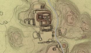
Aerial LiDAR surveys have been popular tools for mapping ancient Maya settlements through the dense rainforest canopy. LiDAR mapping at El Pilar revealed several previously unknown large structures, but many smaller structures in low, swampy areas were invisible to this technique. This project will develop a program of field-checking LiDAR anomalies to clarify the patterns of small structures in seasonal swamps, where settlement models predict people would not live.
More Lab Notes From This Project

Browse Other Projects on Experiment
Related Projects
Development of Low Cost Tent Heaters for Unhoused Populations
For years, makeshift heating solutions for homeless individuals have involved burning unsafe materials like...

Can Community Partnerships Improve Development and Reduce Poaching?
Partnerships and perceptions are key players in curbing poaching and advancing development in rural South...

Creating Youth Historians: How Can History Increase Urban Students' Academic Literacies?
Brilliant children in urban schools all across the country continue to achieve at low academic levels, particularly...
